

This post is a fresh restart of The Island of Sodor scenario and heightmap that were never completed. See viewtopic.php?t=90293 for more details.
---
For the last few years, after a frustrating series of starts and stops, I started over fresh to try to make this more complete and actually release something useful sometime in my lifetime. I may elect to accept some help in the public to get this done. I'm not sure how any of this will go, we'll just see.
This first post will try to keep track of the major achievements of the project, with links to the important posts. If you're contributing, it would be helpful that replies to a post should contain the title of the post you're replying to rather than to the general topic subject in order to keep it somewhat threaded.
The Island of Sodor [2024 Edition]
The Island of Sodor [2024 Edition]
Do you like drones, quadcopters & flying toys? Check out Drone Strike Force!

Base Music Sets: OpenMSX | Scott Joplin Anthology | Traditional Winter Holiday Music | Modern Motion Music
Other Projects: 2CC Trams | Modern Waypoints | Sprite Sandbox & NewGRF Releases | Ideabox | Town Names | Isle of Sodor Scenario | Random Sprite Repository
Misc Topics: My Screenshots | Forgotten NewGRFs | Unfinished Graphics Sets | Stats Shack | GarryG's Auz Sets
[Heightmap] sodor-32gray-4096x4096-2024-05-03
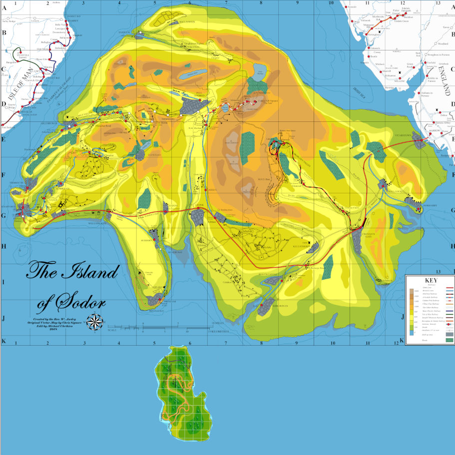
I'm currently developing the heightmap using Paint.Net, where I've imported a few maps and started working from there. The main map, located here ( https://www.deviantart.com/01salty/art/ ... -983187777 ), is a high-resolution map that incorporates land details from several previously released maps as well as details on the locations of cities, important landmarks, road and rail routes. It is the cleanest source that I've found to date.
The first thing I had to work out was the scale depicted on the map through colors and the scale in OpenTTD. The map depicts the highest level as 2000 feet, showed in 8 colors. This is not sufficient enough to show off the steep cliffs and the towering height of Sodor's tallest mountains. I devised that the map would instead be composed of 32 layers. The map must be in 256-shade greyscale, which works out nicely that the step down from the highest level white (#FFFFFF) to sea (#000000) is exactly 8 shades. I believe this worked out very neatly.
Each layer in the source file thus is identified by the color code and level number, which made it very easy for me to start working out the outlines for each level. I started by working on each 8th layer (0, 4, 8, 12, 16, 20, 24, 28, 32), tracing the outline for each layer individually with a bottom map layer to guide me. From there I worked out the outlines from sea level upward to carve out pathways for rivers and valleys, and also from the highest peaks downward to define mountains and plains. Since there is no guides on what landscape looks like in-between, I used a lot of artistic license and tried to imagine how the landscape would flow as it transitions from the mountains to the sea, imagining how creeks and rivers carved the land up.
This took me a few hundred hours over a period of a year to generate. I think the end result looks SO much better. But since I am not intimately familiar with The Railway Series or the modern Thomas interpretations, I don't know how faithful this is to what is depicted in the books and shows. I'm only working off of what I can see on the map. To that end, it feels to me that most of the coast line is steep, rocky shores with a few beaches and low-laying swamp. Likewise, the estuaries lead inland to narrow rivers that carved out deep valleys. Unfortunately there's no great way to create rolling hills, but you do with it what you can.
Anyhow, attached is a sample heightmap file. It is 4096x4096, counter-clockwise orientation with a max height of 32.
- heightmap-snapshot-2024-05-03.png (330.24 KiB) Viewed 395 times
- Attachments
-
- sodor-32gray-4096x4096-2024-05-03.png
- Heightmap
- (1.2 MiB) Not downloaded yet
Do you like drones, quadcopters & flying toys? Check out Drone Strike Force!
Base Music Sets: OpenMSX | Scott Joplin Anthology | Traditional Winter Holiday Music | Modern Motion Music
Other Projects: 2CC Trams | Modern Waypoints | Sprite Sandbox & NewGRF Releases | Ideabox | Town Names | Isle of Sodor Scenario | Random Sprite Repository
Misc Topics: My Screenshots | Forgotten NewGRFs | Unfinished Graphics Sets | Stats Shack | GarryG's Auz Sets
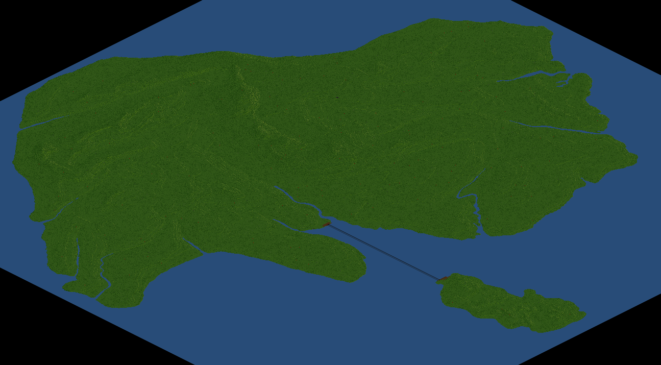
Adding Misty Island
I believe I've largely finished developing the landscape for Sodor, but there's still room on the map for other stuff. Namely, Barrow-in-Furness to the east, Isle of Man to the west... and Misty Island to the south.
I known Misty Island, for many years, was an unspeakable abomination to the canon for many, and as it appears to have been either ignored or dropped in the last several years, there's debate about whether it actually is canon. However, there was a generation of Thomas fans who grew up with it and now have an affinity for it. So I think it's fair to give it some space.
The only question is, where? And how much? Unfortunately there's almost no history or back story to it, and it doesn't appear on any official maps. The only visual representation that we have had is from the CGI DVD and video game releases, which depicts it as a massive island - almost as large as Sodor itself, south of Sodor. Unfortunately these renderings are not at all in any realistic scale. So, we must use our imagination and common sense in trying to place it.
I've only seen two fan renderings trying to place it. One depicted it east of Brendam, a smaller island wedged into the bay, and the other depicted it as a much larger island south of Brendam.
I've decided to go south as well, and to also go with a larger island, but not where the fan placed it. The reason why is largely to do with the old Misty Island Tunnel. For this to work in OpenTTD, you'd have to use the JGR Patch Pack (which I'm supportive of, but not designing this exclusively for) to use the Chunnel patch to make a tunnel under the sea. For that to work the island has to be aligned with wherever the tunnel starts, so this is going to put it in a specific area on Sodor, near where the Search & Rescue Center is built. So I must align the island to make that happen.
I also went with the larger island in order to fill some of the space. If we were trying to be consistent with The Railway Series and Sodor's realistic placement then that space would be filled with a lot of UK. But Sodor isn't really about the UK and that area of the UK was never part of the stories like Barrow and, to a smaller degree, Isle of Man. So I'm not going to fill it with that, and nor am I going to fill it with all of Isle of Man or Cumbria, just the parts that were seen in the official maps. I don't even plan on really working on infrastructure for those places.
So, anyhow, here's my rendering of Sodor, Man, Barrow and Misty Island. And if players don't like it, they never have to interact with it, just treat it as nothing.

- Attachments
-
- screenshot.png
- (651.6 KiB) Not downloaded yet
Do you like drones, quadcopters & flying toys? Check out Drone Strike Force!
Base Music Sets: OpenMSX | Scott Joplin Anthology | Traditional Winter Holiday Music | Modern Motion Music
Other Projects: 2CC Trams | Modern Waypoints | Sprite Sandbox & NewGRF Releases | Ideabox | Town Names | Isle of Sodor Scenario | Random Sprite Repository
Misc Topics: My Screenshots | Forgotten NewGRFs | Unfinished Graphics Sets | Stats Shack | GarryG's Auz Sets
Base Music Sets: OpenMSX | Scott Joplin Anthology | Traditional Winter Holiday Music | Modern Motion Music
Other Projects: 2CC Trams | Modern Waypoints | Sprite Sandbox & NewGRF Releases | Ideabox | Town Names | Isle of Sodor Scenario | Random Sprite Repository
Misc Topics: My Screenshots | Forgotten NewGRFs | Unfinished Graphics Sets | Stats Shack | GarryG's Auz Sets
Re: Adding Misty Island
Here is my first attempt at landscaping Misty Island. overall I think I'm happy with it? I didn't want it to be too mountainous, my thinking is that it's just mostly going to be used for logging (Jobi trees, of course!) and maybe a tourist destination in the south.
Under JGRPP, building a Chunnel is going to be very expensive, over $500,000,000 per tunnel. It will run from the northern-most tip of Misty Island to the southern-most tip of the peninsula south of Maron. And not as depicted in the DVD series, but again that's the compromise of the game itself. You can always build some docks and take a slow ship. Per the TV show map scale it's only about 10 miles away, but in-game it's 1800 tiles. I'd definitely suggest building two tunnels, even with signals in tunnels it's gonna take awhile for a train to get from one end to the other.
I contoured the landscape so that it would give you a clue as to where to lay in the small river, plus roads and rail. Some of these probably need steeper, higher landscapes around it (Echo Valley, for example), but if somebody really cared they could build that up. Maybe I will in the scenario.
Anyhow, feedback appreciated.
- Attachments
-
- sodor-32gray-4096x4096-2024-05-05.png
- (1.29 MiB) Not downloaded yet
-
- screenshot.png
- (243.05 KiB) Not downloaded yet
Do you like drones, quadcopters & flying toys? Check out Drone Strike Force!
Base Music Sets: OpenMSX | Scott Joplin Anthology | Traditional Winter Holiday Music | Modern Motion Music
Other Projects: 2CC Trams | Modern Waypoints | Sprite Sandbox & NewGRF Releases | Ideabox | Town Names | Isle of Sodor Scenario | Random Sprite Repository
Misc Topics: My Screenshots | Forgotten NewGRFs | Unfinished Graphics Sets | Stats Shack | GarryG's Auz Sets
Base Music Sets: OpenMSX | Scott Joplin Anthology | Traditional Winter Holiday Music | Modern Motion Music
Other Projects: 2CC Trams | Modern Waypoints | Sprite Sandbox & NewGRF Releases | Ideabox | Town Names | Isle of Sodor Scenario | Random Sprite Repository
Misc Topics: My Screenshots | Forgotten NewGRFs | Unfinished Graphics Sets | Stats Shack | GarryG's Auz Sets
New rivers!
Today's goal was to get started on the rest of the landscapes. I look at England and the shape from the official maps is ALL wrong, I don't even know where to get start. So I switched to isle of Man... which is also not shaped right! No matter, we can just edit it out and put the right one in. I decided to orient the island so that all of Douglas was in the game, and worked from there The real Ramsey Bay to the north cuts much further inland than on the Sodor maps, but I think the realism takes precedent.
I was able to find a topological map that broke out the height levels in color. It's not in the same color scale that the Sodor map uses, but I figured out the conversion. The peak mountain on Isle of Man is 614 feet, or about 1/3 of the highest point in Sodor, so I'm going to shade it using the first 11 levels. Before I do that, though, i also need to know where the rivers run. There's a LOT of rivers on Isle of Man! I had to use several maps which drew out where the rivers were at, overlaid them and painted the river paths on, then I had to align the rivers with the topological map to make sure they were in the exact right place. This has taken me a full seven hours to do, but the results are quite good, if I may say.
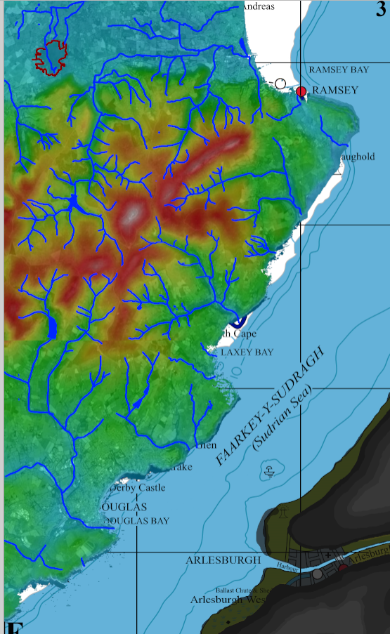
I was able to find a topological map that broke out the height levels in color. It's not in the same color scale that the Sodor map uses, but I figured out the conversion. The peak mountain on Isle of Man is 614 feet, or about 1/3 of the highest point in Sodor, so I'm going to shade it using the first 11 levels. Before I do that, though, i also need to know where the rivers run. There's a LOT of rivers on Isle of Man! I had to use several maps which drew out where the rivers were at, overlaid them and painted the river paths on, then I had to align the rivers with the topological map to make sure they were in the exact right place. This has taken me a full seven hours to do, but the results are quite good, if I may say.
- Attachments
-
- screenshot.png
- (829.7 KiB) Not downloaded yet
Do you like drones, quadcopters & flying toys? Check out Drone Strike Force!
Base Music Sets: OpenMSX | Scott Joplin Anthology | Traditional Winter Holiday Music | Modern Motion Music
Other Projects: 2CC Trams | Modern Waypoints | Sprite Sandbox & NewGRF Releases | Ideabox | Town Names | Isle of Sodor Scenario | Random Sprite Repository
Misc Topics: My Screenshots | Forgotten NewGRFs | Unfinished Graphics Sets | Stats Shack | GarryG's Auz Sets
Base Music Sets: OpenMSX | Scott Joplin Anthology | Traditional Winter Holiday Music | Modern Motion Music
Other Projects: 2CC Trams | Modern Waypoints | Sprite Sandbox & NewGRF Releases | Ideabox | Town Names | Isle of Sodor Scenario | Random Sprite Repository
Misc Topics: My Screenshots | Forgotten NewGRFs | Unfinished Graphics Sets | Stats Shack | GarryG's Auz Sets
New rivers!
What am I up to today? I'm drawing rivers. Yesterday while working on the Isle of Man side I traced out all the rivers so that when I started working on the topological layers that I could have some more guidance. That got me thinking about the fact that on the Sodor side, other than a few big rivers there were no tributaries or streams or creeks mapped out, and I wondered what that would be like and how much of a pain it would be to make on my own. As luck would have it, somebody on DeviantArt had a similar idea and created their own Sodor map with "enhancements" and their own headcanon about where stuff goes. Now, a lot of it doesn't like up with the topology that I've drawn, but it gives me a idea of where to draw some rivers in and it's less painful. Still work, but less. I've got about half of the rivers for Sodor mapped out now, and if I find some more accurate authoritative work then I'll have to redo it. But it will make the map more interesting once we get to working on the scenario.
- Attachments
-
- screenshot.png (339.83 KiB) Viewed 186 times
Do you like drones, quadcopters & flying toys? Check out Drone Strike Force!
Base Music Sets: OpenMSX | Scott Joplin Anthology | Traditional Winter Holiday Music | Modern Motion Music
Other Projects: 2CC Trams | Modern Waypoints | Sprite Sandbox & NewGRF Releases | Ideabox | Town Names | Isle of Sodor Scenario | Random Sprite Repository
Misc Topics: My Screenshots | Forgotten NewGRFs | Unfinished Graphics Sets | Stats Shack | GarryG's Auz Sets
Base Music Sets: OpenMSX | Scott Joplin Anthology | Traditional Winter Holiday Music | Modern Motion Music
Other Projects: 2CC Trams | Modern Waypoints | Sprite Sandbox & NewGRF Releases | Ideabox | Town Names | Isle of Sodor Scenario | Random Sprite Repository
Misc Topics: My Screenshots | Forgotten NewGRFs | Unfinished Graphics Sets | Stats Shack | GarryG's Auz Sets
Who is online
Users browsing this forum: No registered users and 3 guests