Long time no see! OpenTTD has captured my imagination again, so it's time to start a new game. I can't promise frequent updates, but will post them as time and motivation allow. Let's get the introduction out of the way first.
The premise
Instead of starting in the early 1900s as usual, I wanted to have a go at a more modern scenario, so this time around 1977 shall be it. Another major change is the way the map is set up: ordinarily, I'd just place small towns here and there and connect them in classic TTD style. Here, I've crafted myself a metropolitan area by the name of Kenton, which consists of several individual districts with a combined population of well over 200.000. This will give me an opportunity to try my hand at somewhat realistically sized urban transportation. There's also a pre-built network of highways and secondary rural roads to every single settlement on the map. Distribution of industry is about 30% auto, 70% manual. Shaping all of this was a task that took many, many hours to complete...
The setup
I'm still using my ancient version of OpenTTD (r24113M) patched with tunnel/bridge signals and daylength, but it works just fine for me. General settings:
- Day-length factor of 20
- Realistic acceleration (RVs, trains)
- Slope steepness of 3 % (do.)
- Weight multiplier of one
- Plane speed factor of 1/1
- Breakdowns disabled
Yes, 20. Even with a factor of 12 in my previous game, I found that the glut of passengers generated by larger towns could quite easily be overwhelming. At the maximum setting, I should be able to move all these people with a more reasonable number of vehicles (especially buses and trams). Rural branch lines shouldn't be a problem, either. On the downside, the slow passage of time means I'm going to be stuck with the same vehicles for many years to come.
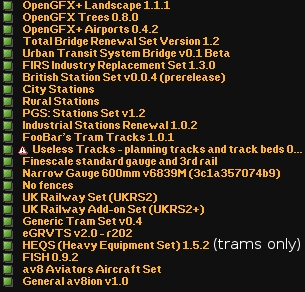
NewGRFs are mostly the same:
 The infrastructure
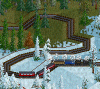
My approach could best be described as mildly realistic with low terraforming. I've seen enough rail infrastructure in real life and on my monitor to have a good idea as to what extent of earthmoving could be considered appropriate, and I think I have it pretty much nailed down in OpenTTD terms at this point. Four-track main lines and grade separation will be used sparsely where traffic demands it. Construction of rails and roads will have to account for the terrain; again this is a quite mountainous map.
The rolling stock
Trains
Most likely going to be the primary mode of transport. 1977 as opposed to 1975 was chosen specifically because of the introduction date of the BR Class 313. Overall, lots of capable diesels, electrics and D/EMUs available, and the modern freight wagons will allow me to design mixed passenger and freight traffic at 120 kph without having to worry about speed limits in the future. In the early 1900s, freight trains are of course restricted to either 64 or 88 kph, and upgrading means having to manually redo all those timetables as well. Not fun times...
Also, long daylength = cargo generated over a extended period of time = shorter trains = an opportunity for light engines you wouldn't normally find a use for. Additionally, I'm looking forward to integrating McZapkie's
600mm trains somewhere.
Road vehicles
There will be a tram network in Kenton. I might also use freight trams, but certainly not to the extent of my previous game. There's really no need for that if carrying capacity isn't the primary consideration; trucks of the late 1970s are fast enough and perfectly usable unlike their distant predecessors. Otherwise, trucks and buses will probably find their place mostly for short distances or to fill in gaps in the rail network. Exceptions are possible since there's already motorways and stuff ready to use.
Ships
Well, there is plenty of water around. And fishing grounds, oil rigs and dredging sites. Probably no canal this time.
Aircraft
Helicopters will definitely make an appearance and turboprop commuter planes might fly to very remote communities. As for the rest, I can't really see a use for anything else but long-distance mail, and that's a very big maybe. And yeah, I've patched out the limited range feature in my copy of AV8.